Middle Sand Creek Corridor Restoration Project
The Coon Creek Watershed District (CCWD) was awarded funding in 2018 for the Middle Sand Creek Corridor Restoration Project with an US EPA 319 grant of $291,000 and a Minnesota Clean Water Land and Legacy Fund grant for $382,772. Click here for the 2021 All Details Grant Report
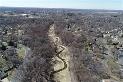
The goal of this project is to improve fish and wildlife habitat in and adjacent to the creek channel and to reduce Total Suspended Solids (TSS) and phosphorus concentrations while also providing long-term channel stability. This project is another step towards meeting Clean Water Act standards for Sand Creek.
The project is located along a nearly 2/3-mile stretch of Sand Creek from the pedestrian bridge at Kumquat Street downstream to the railroad tracks. These railroad tracks are the upstream end of the Lower Sand Creek Corridor Restoration Project of 2018-19.
This project is Completed! The vegetation in the project area will be maintained for three years to help the native plants get established.
Click here for a 3-minute time-lapse video of project construction ( YouTube link)
Click here to watch this animation on how & why rivers curve
It will help you understand the project design.
Background
Sand Creek is currently listed as Impaired for failing to meet federal Clean Water Act standards for aquatic life due to excess sediment (Total Suspended Solids), phosphorus, poor habitat, and altered hydrology. By re-designing the creek channel and its adjacent corridor, we hope to reduce these issues and help get Sand Creek back to meeting water quality standards.
Design work for the channel has been done in collaboration with the Minnesota Department of Natural Resources. A type of Natural Channel Design has been chosen.
Questions? Contact Justine Dauphinais, Water Quality Coordinator at Coon Creek Watershed District. Phone: 763-755-0975.